Church Views - A Walk from Arkesden
|
Church Views - A Walk from Arkesden |
Getting there
Take the A1301 south out of Great Shelford, down the Sawston by-
pass, cross the A505, and at Stump Cross take the B1383 towards Newport. Just
beyond Audley House, turn right towards Royston on the B1039, go under the
Mil, and soon afterwards turn left to Arkesden, as the Royston Road bears right.
In the village bear left, parking carefully opposite the Axe and Compass, not
blocking entrances and bridges over the stream.
Pub(s) The Axe and Compasses, Arkesden
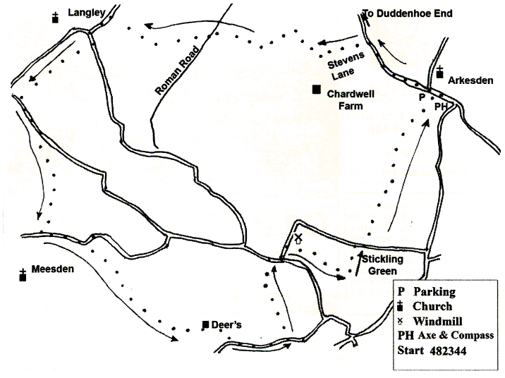
The Walk
The walk is about 8 or 9 miles, and will take about 4 hours. Like all paths, these
can be muddy!
Walk back towards the junction, do not take right back past the church, but go up the lane straight ahead, towards Duddenhoe End. Soon after a farm entrance to Chardwell Farm, look for tree-lined track to the left (Steven's Lane). Follow this track uphill, and as it swings to the right at a wood.
Follow up to a T junction, and head left through a hedge labelled with a Public Footpath sign (not up the house drive labelled private!) Follow this track up the rise, and as it drops to a Y junction, where you bear right. Keep going along this field edge path till you reach a track (Roman Road), turn left, cross a stream, and almost immediately turn right along a field edge path, which bends right through a gap, and brings you out to a road.
Turn left, keep on the road as it crosses the cricket field, and turn left (to look around Langley Church make quick diversion to the right, and come back to same point).
Keep on this road, signed to Clavering, and soon spot path to the right beside a cottage. Take this path to emerge onto a quiet road, and turn left (pub a short distance to right). After the houses finish, look carefully on the right for a footpath sign set back from the road, cross into the field and turn sharp left along field side and round to stile into pony paddock, then head diagonally across this paddock to gate, after which keep stream on the left and Meesden Church straight ahead on hillside.
Head round field to bungalow with yappy dog, and turn left down road. After short distance bear left over bridge, and immediately turn right on path which follows the river through various twists and turns. Large farm looms on the right, but do not cross bridges to reach it. Head for stile onto substantial path, cross this and take stile into field opposite: have faith, and follow this path - do not attempt to cross the river, but keep on field edges, and then enter the grounds of Deer's, a substantial house and garden. Follow sign down the drive, emerge on to road, and bear left.
After about 400 yards turn left up path, with house on left, and keep going to road, turn right at the road, and then left at top of rise. Just before the windmill, a field edge path takes off to the right: follow this until you come to a cross path, turn left down hill, cross a bridge with metal guard rails, and emerge on to Stickling Green through a narrow passage.
Walk to the right in front of Hobbit Cottage, and head half right to a black Public Footpath sign on the opposite side of the road about 150 yards away. Walk to left in front of the cottage and follow waymark signs through a narrow (wet) defile and emerge to a field edge path, with trees to the right. Follow the path round the edge of the trees, cross a plank bridge, and turn left. Continue on this track as it heads up the rise, first with hedge to the left and then to the right.
Keep heading on, ahead at a cross path, up and then down the slope, with barn conversions to the right. As the stony path swings right and left, go straight ahead on field edge path- This path leads down to Arkesden, and on meeting the road turn right to the Axe and Compass.
Neither the author nor his dog accept any responsibility for accuracy or for any injury or mishap that might befall any person who follows this walk. First published by "one man and his dog" in Great Shelford Village News August 2011