Another lovely walk from Arkesden
 |
Another lovely walk from Arkesden |

Getting There
Take the A 1301
south out of Great Shelford,
down the Sawston by-pass,
cross the A505, and at Stump
Cross take the B1383 towards
Newport. Just beyond Audley
End House, turn right towards
Royston on the B1039, go
under the Mil, and soon
afterwards turn left to
Arkesden, as the Royston Road
bears right. In the village bear
left.
Parking
Park carefully
opposite the Axe and Compass,
not blocking entrances and
bridges over the stream.
The Walk is about
5½ to 6 miles, and will take
about 2½ hours. Most of the
walk is pretty dry (we hope!)
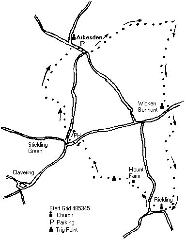
Walk down the village High Street, with the Axe and Compass on
your right, and the post office on your left. Soon, turn left off the main road,
over the weak bridge, and very soon turn left again up the track. Keep on up the
field on an excellent grass track, with ditch to your right; bear right and enter a
wooded section. Emerge and soon after passing under the power lines, turn
right onto a very solid track.
Walk down this track into Wicken Bonhunt. Turn right on reaching the main
road, pass in front of the pub, cross the road and head up green track to right of
house called Greenacres. At top of track, turn right and follow this track as it
winds up the hill, through a gap in the hedge, on up, swing to left and then to
the right. Eventually reach farm buildings and cottages.
Follow the tarmac road round to the right, and after passing barn conversion on
the left, turn right towards Rickling church, and pass through the church yard
with church to your right (bench under the tower). Climb over two stiles, and
turn left along hedge/wall side to reach main road.
Turn right, and after short distance turn up the first farm-drive on the left,
advertising HERBS (this is not the name of the farm). Walk up the drive, and
on reaching the top, turn sharp left, noting waymark on post to reassure
yourself. Enter gardens of Orchard Farm and admire the lovely moated
farmhouse to your right. Walk to the left of the garages, and head for gap in
garden hedge, and then turn sharp right before reaching the field hedge, again
noting waymark to reassure yourself.
Enter delightful wooded track, and at the end turn sharp right up field edge
track. On reaching the top of the rise, you will find another path emerging
through the hedge on your right, which conceals a trig point (a monument to
pre-GPS technology). Turn sharp left along grassy track, under the power lines
again, and then turn sharp right down hill.
Half way down the track, do NOT turn left as track swings left, but carry on
down hill on grassy track. Emerge onto main road and enter Clavering,
swinging sharp in front of the Cricketers (earlier home of Jamie Oliver), and
continue up road, (do NOT turn left to Stickling Green). Country House is soon
followed by Summer House on the left, and after that, opposite a thatched
house, turn left down narrow path with high hedge to left.
Cross over stream, and turn right into field. Now follow the field edge first left,
through a hedge gap, up field edge, turn sharp left with line of trees to your
right, passing sign saying NO HORSES.
As hedge comes up from the left, turn right onto substantial track, and go first
up hill and then down. Keep straight ahead onto field edge path, and head down
hill with village and church coming into view.
This path leads down to Arkesden, and on meeting the road turn right to the
Axe and Compass.
Neither the author nor his dog accept any responsibility for accuracy or for any injury or mishap that might befall any person who follows this walk. First published by "one man and his dog" in Great Shelford Village News June 2005