A longer but charming walk from Stetchworth
 |
A longer but charming walk from Stetchworth |

A local, easy to find, predominantly dry walk, with good views and plenty of wildlife.
Pub(s) The Three Blackbirds, Woodditton
Getting There Take the A11 from Fourwentways towards Newmarket, and turn off to Six Mile Bottom and Newmarket along the A1304. Turn right to Dullingham after about 3 miles, through Dullingham, across the B1061, and into Stetchworth. Turn right at T junction in Stetchworth, and after 600 yards or so turn left to the Ellesmere Centre.(GRTL642582) Explorer Map 210. Park in Sports Centre Car Park
The Walk
The walk is about 11 miles long, with a possible pub stop after 7 or so miles, at the Red Lion, Kirtling Green (shut on Monday lunchtime: 01638 731976). The morning will take about 3 hours, and the afternoon about one and a half hours. Most of the walk is pretty dry (we hope!). Do keep dogs on a close lead; there are horses everywhere at the right time of year.
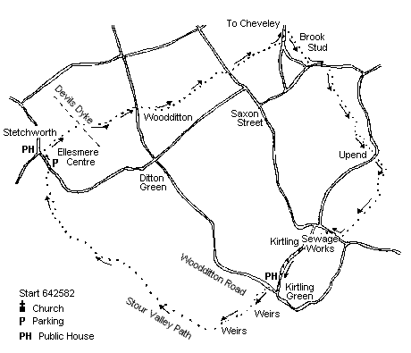
From the Ellesmere Centre walk back to the junction, and opposite the Marquis of Granby, turn right down a footpath, labelled Icknield Way, cross a small road running through an estate of houses, to soon start walking down hill with open land to the right and woodland to the left. At the bottom of the hill, climb up over the Devil's Dyke, go almost straight ahead, along a headland dividing a field. (The right of way is across the field, and muddy, and the farmer has left the headland). At the far side of the field, climb up on to a track and head right, and soon turn left before a copse, up a good track, with hedge on your right. A view of Ely Cathedral is possible on your left as you cross this field.
Soon reach a road. Cross this and go down road to pass the church (Woodditton), and soon after bear left as road swings right (do not turn left!). This path goes straight for some distance, and when it swings left, turn right through the hedge, over a stream and up and across a field. Cross the road, and go down the path opposite, with stud paddocks and stables on either side, and then houses and gardens to the right. On reaching the road, turn left and head towards Cheveley. Soon, there is a small green on the right (with a seat!), turn right here, and head round the back of the Brook Stud, and walk along pleasant green track, again with stud paddocks on either side.
Emerge on to a village green and turn left along the road, and walking on the right hand side of the road, enter the grounds of the Banstead Manor Stud, by a notice indicating the Covering Yard. (The footpath sign is a little overgrown). Go down the tarmac drive, then onto a green track to a small house, over a stile, and along a green track. Bear left, over a road, and on up with hedge to the left and paddocks to the right.
Emerge on to a road, turn right, then through the gateway of a large house, and bear left immediately, with a newly planted hedge on the right. Follow the path round the side of the garden, and the tennis court, then turn sharp left, and left again, with the hedge on the left. Follow the path down into the yard of a stud and turn right along a track, but soon turn left through the hedge, and eventually emerge onto a road in Upend. Turn right and almost immediately left (fingerpost Lidgate) and go down the road until it swings sharp left. At this point turn right, and cross a meadow diagonally into the far corner, where you cross a bridge, turn sharp right to follow a fairly indistinct track through scrubland, soon turning left along a field edge with wood to the left. Turn right on entering a copse at the end of this field, and soon go up hill with field to the left and substantial hedge to the right; through a thick copse, and down to a road. Turn right, and at the bottom of the hill, turn left by the sewage works, along a path to reach a recreation ground. Turn right to pass the pavilion on the right, and through the car park on to the road. Turn left, and after just over half a mile, there is the Red Lion.
Out of the Red Lion turn right, and almost immediately right again into Woodditton Road. Walk along here to a tarmac road turning to the left (signed cul de sac) and follow this down to a stream with substantial weirs. Cross the stream and turn right along the back, passing two or three weirs until a finger post directs you right, back over the stream. Over the bridge turn right, and follow a good path, with wood to the left and field to the right. At a corner, the path dives over a bridge to the left, and then the path goes forward with the wood now on the right, and paddocks to the left. This is the Stour Valley Path, and it goes straight on for perhaps two miles, with wood to the right and paddocks to the left. At the end of this length, the path turns right, and quickly left to cross a field, with the Ellesmere Centre now in sight: down into a dip, cross a path, and over a stile into a paddock, up the hill, over stile onto a grass track with fence to either side. Follow up to the road, and on emerging, turn left, and soon find the Ellesmere Centre.
Neither the author nor his dog accept any responsibility for accuracy or for any injury or mishap that might befall any person who follows this walk. First published by "one man and his dog" in Great Shelford Village News February 2005