The First Village
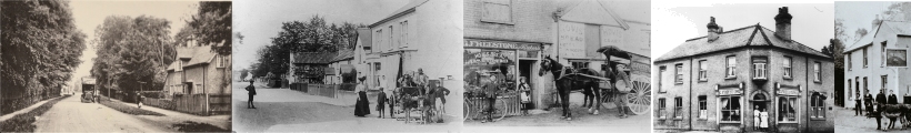
To understand how the present complex arrangement of streets and lanes, lined with houses dating from the 15th to 20th centuries, gradually evolved from a small Saxon village is not easy. Even if we mentally remove from the village a!! the developments of the last 150 years we are still faced with a complicated pattern of streets which is nothing like the early medieval picture. And yet the clues to the original form of the village and its early developments are still preserved all around if we only use our eyes properly and take note of every curious name, every bend in fence or street and think about the position of every house By noticing such things and asking "why" all the time we can begin to see exactly how the village has changed, not only over the last 150 years but over the last 1,500 years. Why, for example, is High Green so called? It is neither high nor green. Why do the customers of Malyon's butcher's shop have to walk up a long drive to reach it, set back as it is from the street? Why is the Square and Compasses public house built slightly askew to the High Street and why has it a wide pavement in front of it which provides a very convenient car park for thirsty travellers? The answers to these and many more curious questions lie in the remote history of the village. They can be explained, but not until they have been noticed and queried. One suspects that such features are never noticed, let alone thought about.
There can be no doubt that the general position of Great Shelford was conditioned by the existence of an early crossing place of the River Cam which coincided with adjacent areas of dry gravel land. Here, where the river cuts through a-narrow gap between the gravel terraces, in sharp contrast to the marshy land both up and down stream, lay the "shallow ford" which gave its name to the village. This ford was probably always important and even in prehistoric times it may have been the route by which travellers coming along the ancient Mare Way, south west of Cambridge, crossed the Cam, moving eastwards to join the great Icknield Way. The earliest Saxon people of Great Shelford who moved into the area probably soon after 400 A. D. must have erected their houses along the little lane coming up from the river which still survives as Church Street. However though the first village lay on a nice dry site, the surrounding land was by no means so attractive. Saxon travellers coming through this village from the west, on reaching the point where the modern street turns sharp left near The Grange, would have found themselves on the edge of a large open area of meadow devoid of all buildings, across which led two tracks. One, the present High Street, led north towards Cambridge and the other, now Wool lard's Lane, east to Stapleford and-Cherry Hinton. This area of meadow was formerly occupied by the old course of the River Cam which once flowed due north across Woodlands Road, Tunwells Lane and just west of Abberley House on its way to Trumpington.
By the early Saxon period, the River Cam had long since taken on its present course but its old bed was and still is occupied by a small north flowing stream. The result of all this was that the village could not expand easily into this area nor indeed could it be used by the farmers there for arable land. It had to be left as meadow-land, and this was no doubt regarded as of great value and extremely convenient so close at hand.
Because of this area of low-lying meadow, the Saxon farmers had to look elsewhere for land for their arable fields. They naturally started to cultivate the land north of the church on the dry chalk and gravel ridge between the River Cam and the present Cambridge Road. But they also crossed the marshy area and cultivated the land east of it i.e. east of Tunwells Lane, land again on dry chalk. This caused the appearance of a long, narrow wedge of meadow land bounded on all sides by arable fields which started near the village and extended in a broad curve N.E. and north, gradually widening until it became part of a strip of meadow running north along the brook to Trumpington.
Most of the boundaries of this meadow land can still be traced on the ground today. Its northern edge left the present High Street just S.E. of the Square and Compasses public house and ran N.E. This is why the public house is set askew to the street. When it was built many hundreds of years later, it was erected on the edge of the meadow land and not on the street. The boundary then ran across the present Burystead Road, behind the Bank and immediately in front of Malyon's butcher's shop, Carlton House and De Freville Farm, all of which were later built on the edge of this meadow. This is why all these buildings are now set back so far from the modern road. The southern boundary of the meadow now no longer exists. It started just east of The Grange and passed behind Powell's Garage and the houses on the south side of Woollard's lane. It then swung N.E. behind the Baptist Chapel in High Street, and across where the police houses now stand. Though no trace of this line remains now it survived until the 19th century. East of Tunwells Lane the boundary of the Saxon meadow can be traced with ease as a line of houses set back from the road. Browning House, Tunwell House and Spanyards are on this line. The boundary then passed across the line of the present railway and joined Granham's Road just south of Granham's Farm.
This then was the setting of the original Saxon Great Shelford. That is a small group of houses along a single street between the River Cam on the west and a broad piece of meadow land to the east.
As time went on the village of Great Shelford started to grow. Most villages when they expand tend to increase in size from the original nucleus and indeed this is what happened at Great Shelford. But here an entirely new settlement also grew up. Some of the inhabitants appear to have moved away from the original village and built themselves a new hamlet which they also called Shelford, though it was some distance from the first village. This other Shelford was set up at the far end of the present village around Granham's Farm. This was a good site, on the edge of the meadow, but on dry chalkland, with its own little stream to provide water. The stream is still there today, for those who look for it, running past Granham's Farm. So probably by 1000 A. D. at the latest, Great Shelford was made up of two distinct parts, the original village around the church and a subsidiary or daughter hamlet at Granham's Farm.
Page last updated October 29th 2009